If you love the trails, chances are you love hills! Maybe even if it’s begrudgingly. Here are the hills that I’ve relied on over the past two years for workouts and race prep on the trails.
SULPHUR SPRINGS
MARTIN ROAD


Length: 0.4KM Elevation: 47M AVG Grade: 12%
Location: Ancaster, ON Parking Lot: Sulphur Springs Parking Lot
Martin Road is a great, runnable hill to do shorter repeats. I like to do 10x2mins up Martin Road, starting from where it starts to ascend and ending at the parking lot. As one of the shorter climbs on the list and an essential part of Sulphur Springs, it’s a favourite of many.
Segment: Martin Rd UH | Strava Run Segment in Ontario, Canada
Crown: (M) – 1m30s, (F) – 1m59s
K2
Length: 0.5KM Elevation: 70M AVG Grade: 14%
Location: Hamilton, ON Parking Lot: Sulphur Springs Parking Lot
K2 is a favourite of many runners in the Hamilton area, for its steep incline and intermittent technicality. You can do a loop going down the other side of the hill, or take the same way you came up back to where you started. I like to do either 3x8mins or 10x2mins up the counter-clockwise direction. Starting from the bottom of the bridge, I can also get a nice 4-minute incline here – which is rare in Ontario.
Segment: CCW K2 Climb | Strava Run Segment in Hamilton, Ontario, Canada
Crown: (M) – 2m16s, (F) – 3m06s
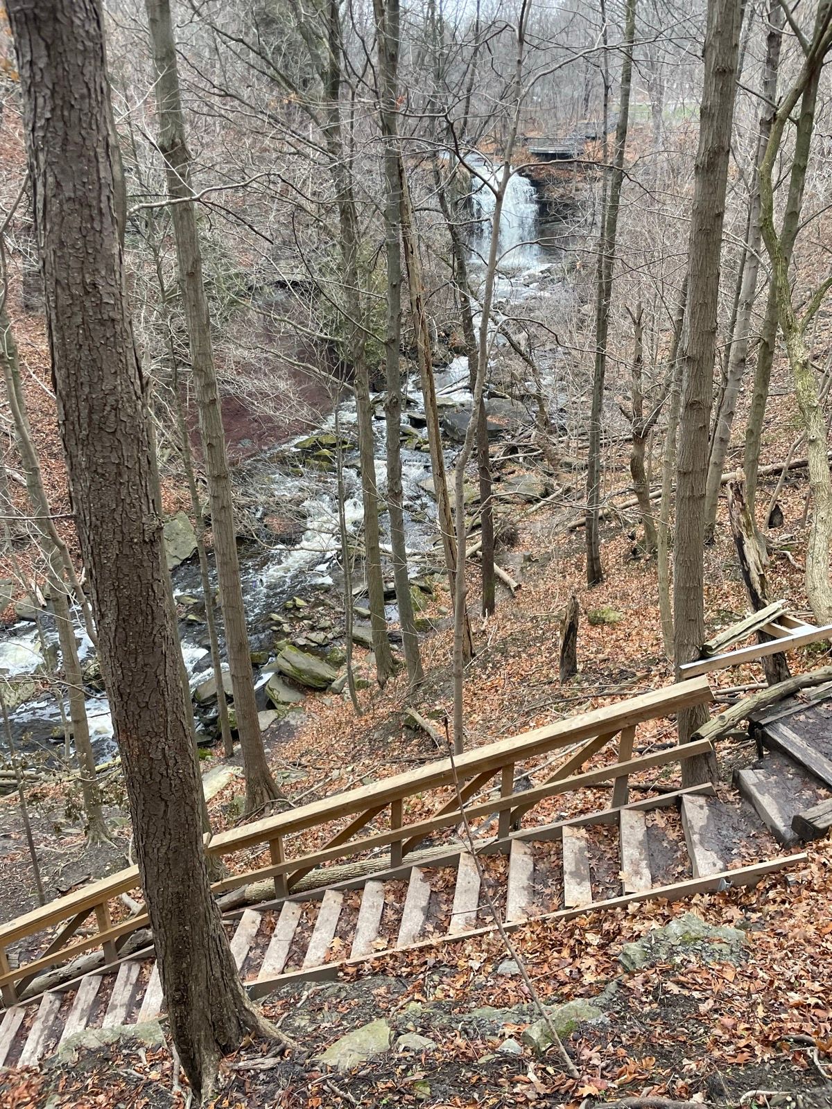
BORER’S FALLS
BORER’S FALLS ASCENT


I have so much fun rocking and rolling up the Borer’s Falls Ascent. It starts at a super technical section that normally makes for an awesomely fun downhill. It then flows into a pretty runnable middle, before a rocky technical finish to the top of some stairs. For a good variety of things, it’s a great one to practice when tackling races outside of Ontario.
Segment: Borer’s Falls Ascent | Strava Run Segment in Ontario, Canada
Crowns: (M) – 3:57, (F) – 4:58
SMOKEY HOLLOW
RAT JAW

Length: 0.2KM Elevation: 67M AVG Grade: 37%
Location: Waterdown, ON Parking Lot: Smokey Hollow Waterfall
Out of all of these segments, Rat Jaw is the gnarliest. It’s super steep, unrunnable, and requires you to change your path quite a few times. It’s best for some hiking adventures, but even at a hiking pace you can find your heart rate soaring high into the skies. It’s so wild that I recommend taking the long way down along Norman Pearson Side Trail (Grindstone Creek Descent), rather than the descent down Rat Jaw itself.
Segment: Rat Jaw | Strava Run Segment in Burlington, Ontario, Canada
Crown: (M) – 1:29, (F) – 1:53
UP TO THE WATERFALL

Length: 0.7KM Elevation: 68M AVG Grade: 10%
Location: Waterdown, ON Parking Lot: Smokey Hollow Waterfall
This segment is wild. Super technical, tons of stairs, very little runnability. Yet if you want to get anywhere on the leaderboard, you need to be running the entire time. Since it’s technical and heavily trafficked, this one is best for an end of run push rather than hill repeats. Always nice to end with a view!
Segment: Up to the Waterfall – Smokey Hollow | Strava Run Segment in Burlington, Ontario, Canada
Crown: (M) – 3:52, (F) – 5:25
BOYNE VALLEY
PRIMROSE TO TOP OF BOYNE VALLEY

Length: 1.1KM Elevation: 96M AVG Grade: 8%
Location: Shelburne, ON Parking Lot: Bruce Trail Parking @ Boyne Valley
I love this hill. It’s the perfect mix of steep, technical, and runnable. I know that sounds odd, but it’s a really easy one to settle into a groove as it ascends to the top of Boyne Valley with an awesome view. The toughest part comes right at the end, when the gradient goes bonkers. But there’s one section in between the two big climbs that flows nicely to give you a partial break. It would be another great one for a longer hill rep, taking about 7-10 minutes to ascend.
Segment: Primrose Side Trail to Top of Boyne Valley | Strava Run Segment in Mulmur, Ontario, Canada
Crown: (M) – 7:14, (F) – 9:04
PRETTY RIVER
PARKING LOT TO HIGHEST POINT


Length: 3.2KM Elevation: 343M AVG Grade: 8%
Location: The Blue Mountains, ON Parking Lot: Pretty River Parking Lot
Ahead of Gorge Waterfalls 50K in April 2024, I looked into ways that I could get a consecutive uphill for longer than twenty-minutes. I stumbled upon two ways to get something similar enough in Pretty River, and this is my favourite. This is the best way to get a consecutive 25-30-minute uphill in Ontario. There’s just one small section of downhill, but also a great mix of technical rock and root with some steep hiking sections. Importantly for those racing outside of the province, it gives you a chance to practice what it’s like to keep the heart-rate down over a longer ascent. If looking for something slightly shorter, you can also start just after the downhill section once crossing Pretty River. That makes for a fifteen minute uphill for me, with 229m of climbing across 2k.
Segment: Pretty River Rd. Parking Lot Climb to Highest Point of Bruce Trail | Strava Run Segment in The Blue Mountains, Ontario, Canada
Crown: (M) – 25:50.
PRETTY RIVER ROAD CLIMB

Length: 1.5KM* Elevation: 94M AVG Grade: 5%*
Location: The Blue Mountains, ON Parking Lot: Pretty River Parking Lot
Undoubtedly one of the best climbs on this list, the Pretty River Road Climb starts from the parking lot near the park and goes all the way up to where you can catch up with the uphill section listed above. It’s covered in rocks, super steep in some sections, and takes a lot to continue running for the entire ten minutes. *Whoever created the segment mapped it at a slightly weird spot, but if you just go to the top of the hill about a kilometre in, it works wonders for longer uphill repeats at a sweet grade.
Segment: Pretty River Rd Climb | Strava Run Segment in Nottawa, ON, Canada
Crown: (M) – 9:42, (F) – 10:20.
FALLING WATER
GRAHAM’S HILL CLIMB
Length: 1.4KM Elevation: 127M AVG Grade: 8%
Location: Flesherton, ON Parking Lot: Bruce Trail Parking @ Concession Rd. 12A
As part of the Falling Water Trail Marathon, Graham’s Hill Climb gets quite the reputation up in Beaver Valley. It’s a long, 1500m climb, ascending over 100m of elevation gain across about 10 minutes of running slow. It’s not trail, but an essential part of connecting the Bruce Trail to different sections of the Falling Water course. It would be a great hill to tackle for longer efforts uphill, and some sustained downhill going back the other way.
Segment: Graham’s Hill Climb | Strava Run Segment in Ontario, Canada
Crown: (M) – 7:21, (F) – 8:03
MONO – BRUCE TRAIL
SALLY & DAVE

Length: 0.5KM Elevation: 64M AVG Grade: 12%
Location: Mono, ON Parking Lot: Bruce Trail Parking @ 5th Line EHS
Winding, steep, and long! This hill reminds me of the start at Gorge Waterfalls – just winding singletrack one step to the next. Super runnable, but still difficult. Something about the air hits different on Sally & Dave, making it harder to ascend. It took me just under 3-minutes when I set the CR, but it always feels like longer. This is also the best place to park for the Bruce Trail in Mono, which is far and away the best part of Hockley Valley.
Segment: Sally and Dave | Strava Run Segment in Mono, Ontario, Canada
Crowns: (M) – 2:52. (F) – 3:14.
UP, UP, UP!

Length: 0.5KM Elevation: 65M AVG Grade: 14%
Location: Mono, ON Parking Lot: Bruce Trail Parking @ 5th Line EHS
Another favourite of mine, Up, Up, Up is one of the more difficult on the list for its excessive stair technicality. It winds left and right along steep stairs, and never ends, even when you feel like it’s about to. It takes about as long as Sally & Dave, but feels so much tougher. So if you want a runnable hill that you can flow, do Sally & Dave. If you want something gnarlier, do Up, Up, Up!
Segment: Up Up Up | Strava Run Segment in Orangeville, Ontario, Canada
Crowns: (M) – 2:39, (F) – 4:00
If I’ve missed any that need to be included let me know! These are just a few of my favourites to help you on your way to crushing uphills out on the trails. Thanks for reading and see you soon!